The Royal Mile
“It is one of the most hauntingly beautiful places in the world, the history is fascinating, the men are handsome, and the whisky is delicious.”

Today’s tale (Nov 18) begins where all good stories must—with a good breakfast!

Three cheers to The Bearded Baker for preparing this morning’s confectionary delights: freshly baked cinnamon rolls, mocha, and hot chocolate—all vegan and all exceptionally delicious!
The Royal Mile
“Edinburgh sloped up behind me to the glowering heights of Edinburgh Castle, and down before me, to the gracious majesty of Holyrood Palace.”
Why is Edinburgh endlessly fascinating? As a 22-year-resident of Paso Robles I can tell you that my city derives its name from some vague reference to an oak pass, outlaws Jesse and Frank James soaked in the local hot springs, and Spring Street is named after, well, you guessed it.
Perhaps the average person living in Edinburgh is equally ambivalent about the history they pass daily. Maybe this is why we travel, because “somewhere else” is novel and, as such, exotic. But just consider this: Paso Robles became a city in 1857. Now drop the 1, and we are in the realm of Edinburgh’s origination story—a full millennia earlier.
The name Edinburgh essentially means Eyden hillfort. But I’m finding the subtleties infinitely more intriguing. Take for example The Royal Mile, which runs through the heart of Edinburgh’s Old Town. It connects the magnificent Edinburgh Castle, perched high on a base of volcanic rock, with the Palace of Holyroodhouse, resting in the shadow of Arthur's Seat. The continuous thoroughfare of the Royal Mile actually consists of five different streets: Abbey Strand (not pictured below), Canongate, High Street, Lawnmarket, and Castlehill.


Reading the five street names I’m immediately reminded of Ken Follett’s Pillars of the Earth, where he vividly described the origins of medieval villages and how names often follow function.
Abbey Strand—The lowest part of the Royal Mile is the block-long Abbey Strand, just outside the 12th century Holyrood Abbey.
Canongate—Abbey Strand gives way to Canongate. I initially made the mistake of not recalling that a cannon shoots cannonballs. However, Holyrood Abbey was home to Augustinian canons, or priests. There was a wall around the abbey and a boundary ditch just beyond the abbey, and of course a gate—thus the name Canongate.

Near the bottom of Canongate, this circle of beige cobbles set into the road is the Girth Cross (aka Abbey Cross or South Cross). The Girth Cross was an ornamental cross elevated on a flight of steps, which marked the western limit of the Girth of Holyrood, and thus the sanctuary zone of Holyrood Abbey. It was also a place for announcements and executions. It must have been very near the abbey’s gate.

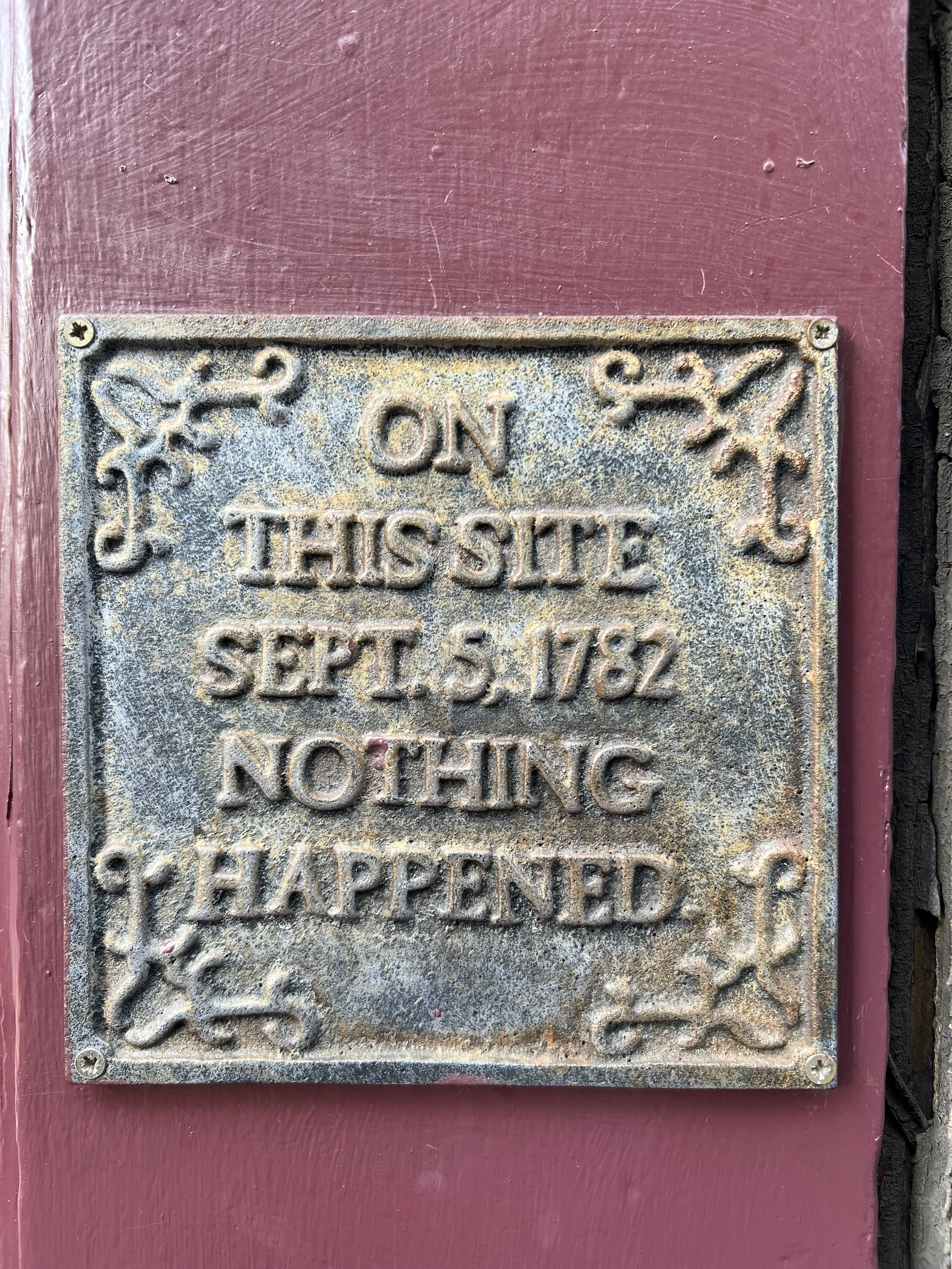
Back in the days, Edinburgh was divided into two areas: the Royal Burgh and Canongate. Built in 1591, the Tolbooth was located in the middle of both areas and was used to collect tolls from travelers who wanted to enter the Royal Burgh. Over the years it also served as a council chamber, police court, and prison. The building is utterly fantastic!

Check out the wee door on the right.

Much like the Girth Cross at the bottom of Canongate, this Maltese Cross is set into the road near the top of Canongate. It marks the site of the original standing cross of St John. This cross originally marked the boundary between Edinburgh and the Royal Burgh and Canongate (perhaps before there was a formal gate?). The original cross is now located in the churchyard of Canongate Kirk to the east of the marker.

High Street—As you continue up the Royal Mile, the street changes names from Canongate to High Street.

The Netherbow Port gate to the Royal Burgh was situated here. This is also where you’ll find the End of the World Pub, so named because it marked the end of the city and outside the gates was considered another world. The foundation of the pub contains part of Edinburgh's ancient Flodden Wall, which used to protect the Royal Burgh—what is now known as Edinburgh's historic Old Town.

Outside the pub, brass cobbles in the road show where the city gates once stood.

In the 1100s, the main commercial or shopping streets were often referred to as High Street. Most of the street names on Edinburgh’s High Street end with the word “market.” Off High Street you will find Old Fishmarket Close and the lovely and evocative Fleshmarket Close, where all the town’s butchers slaughtered animals and the blood literally ran down the cobbles and into the nasty Nor’ Loch (present day Princes Street Gardens).

Smack dab in the middle of High Street is Christ’s Kirk at the Tron (that’s me in the bright blue jacket on the front steps). The name was later simply shortened to The Tron. There was once “salt-tron”—a public weighing beam—just outside the church. This was an important gathering point, where goods were measured and minor criminals punished. I’ve researched it extensively but can’t seem to find information on what the special cobbles in front of the Tron Kirk mark.

Though many do not today, most closes on High Street originally would have had a gate on the street to close them off at night. The passageways lead off the main road to backstreets and small courtyards, where the wealthier merchants lived. These closes are endlessly fascinating to explore.

Near the top of High Street sits St. Giles Cathedral. We attended the 11:00 service on Sunday and I must say I really enjoyed the sermon (starts at the 34-minute mark). Worshippers have been gathering here for nearly 900 years! The interior is spectacular and the acoustics for the choir simply amazing. When the choir sang Sedebit Dominus Rex, I closed my eyes and just listened. It was like having on a set of Bose headphones. The choirs’ control from crescendo to diminuendo in four-part harmony was masterful; the sound filled the space and brought tears to my eyes. (If you click the sermon link above, the song begins at the 45-minute mark). We’ve booked tickets to return to sing Christmas Favourites on the evening of December 10.

Amanda is standing on the Heart of Midlothian. This mosaic just outside St. Gile’s front doors is a deceptively sinister marker. The heart indicates the location of the entrance to Edinburgh’s Old Tolbooth (and Ebinburgh’s main jail), which was demolished in 1817. Locals will often spit upon the heart. While the tradition is now one of good luck, it was originally done as a sign of distain for the torture and executions that took place in the Old Tolbooth.
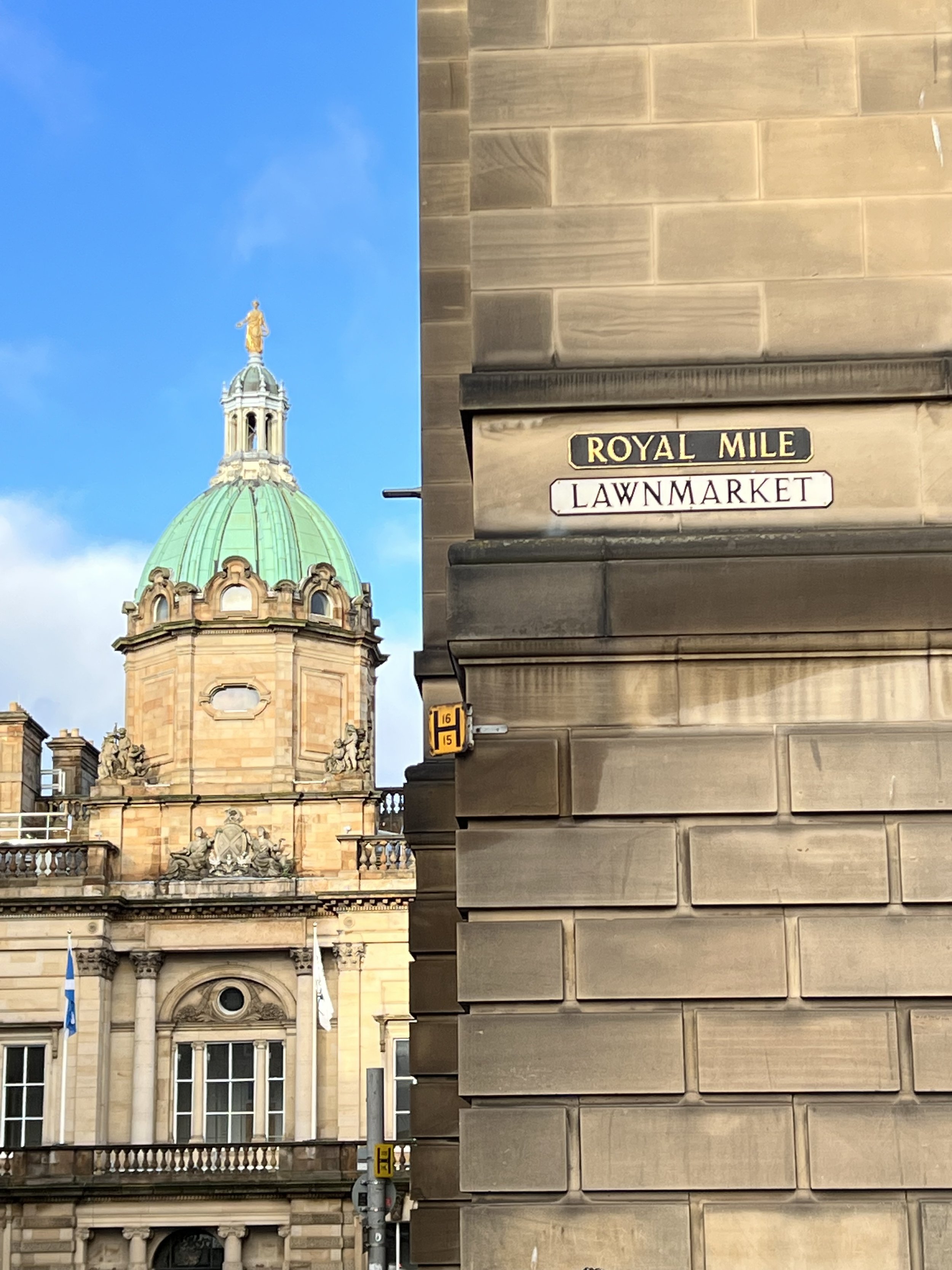
Lawnmarket—Just up the hill from St Gile’s Cathedral, the Royal Mile changes names a fourth time. The Lawnmarket section of The Royal Mile was originally a market area specializing in cloth or linen. (The name Lawnmarket likely derives from a corruption of the French translation of linen, “lin,” or possibly from the Scots pronunciation of “land,” as “laun.”)
Like High Street, Lawnmarket is full of closes—each named for the city’s wealthiest people, tradesmen, or artisans who lived there.

As you near the castle, you leave Lawnmarket and the street names changes one final time to Castlehill (pretty self-explanatory really).

Castlehill includes the old Tolbooth Kirk, which is now a business and not a church at all. Its spire is the highest point in Edinburgh.

Close—An alleyway that leads to a private property, hence they are often gated.

Wynd—A narrow lane between two houses, an open thoroughfare usually wide enough for a horse and cart.

Vennel—A passageway between the gables of two buildings, which can in effect be a minor street in Edinburgh.

The Vennel

Amanda on “the” Vennel, back against the Flodden Wall (one of the city’s original fortifications, with only a few small sections surviving). The openings are arrow slits.
One final thought…