County Kerry
“May your joys be as deep as the oceans
Your troubles as light as its foam
And may you find sweet peace of mind
Wherever you may roam.”

Farewell to the amazing Earlson’s Farmhouse southwest of Limerick. It was fun to call this late 17th century building our home for five nights.

We are grateful to our hosts Anne and Dan for the wonderful stay.
Muckross House
After leaving Earlson’s, it took a bit over an hour to arrive at Muckross House, which is situated inside Killarney National Park, County Kerry.

Muckross House was completed in 1843 for the Herbert family, who hosted the English Queen Victoria and members of her family in August 1861. The boudoir, dressing room, and bedroom used by Queen Victoria have been restored to how they appeared during her visit.
The Herbert family eventually sold the property to a member of the Guinness family. In 1911, it was then bought by a wealthy American couple who gave it to their daughter. When their daughter died unexpectedly in 1929, the house and its estate were presented to the Irish Nation. Muckross became Ireland’s first National Park in January 1933.
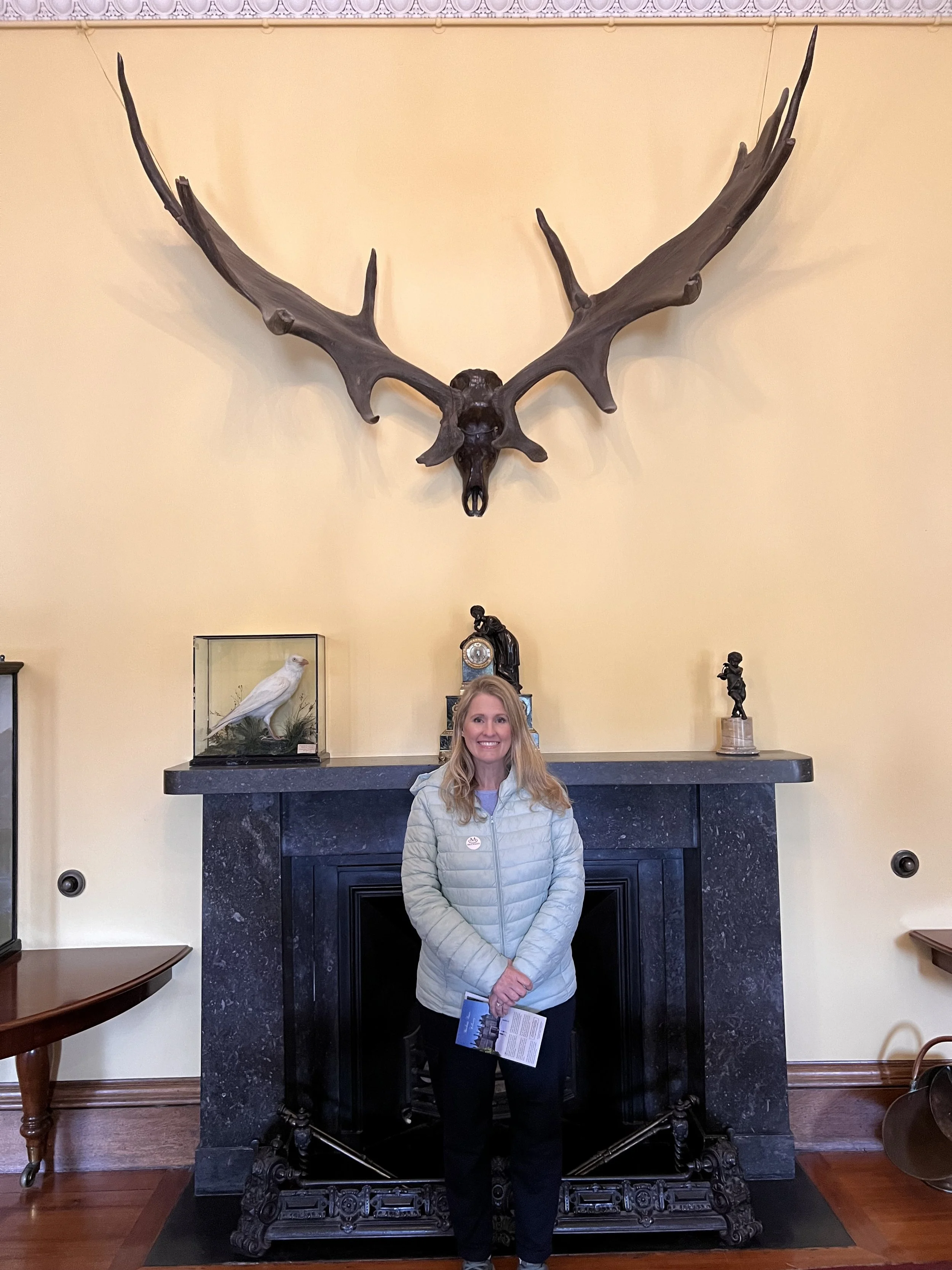
In the entrance hall are the antlers of a Great Irish Elk, which became extinct over 10,000 years ago.

A large old English crystal frosted window overlooks the grand oak staircase.


The bell corridor. Each bell had its own tone, so the servants knew, almost without glancing, which room they were being summoned to “above stairs.”

At the end of the bell corridor was the wine cellar. The numbered stalls were reminiscent of those found in Edinburgh’s South Bridge vaults.
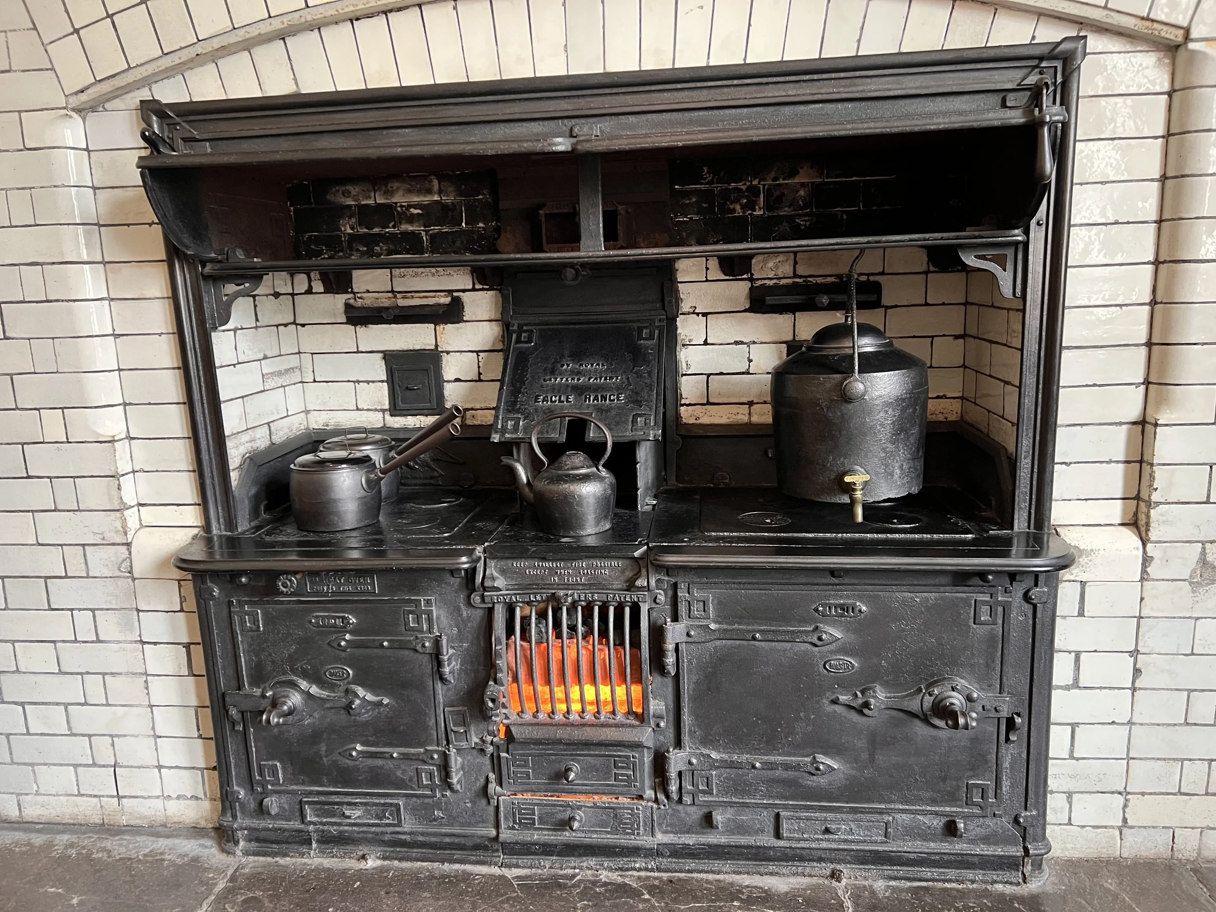
Amazing original Eagle Range.

The west elevation of the house, where every room overlooks the massive lawn, which leads to Muckross Lake.

Muckross Lake.
€0.10c
After visiting Muchross House we went to the Tesco Superstore in Killarney.

As we were walking out, Amanda spotted a single coin on the floor.

Of course it was ten cents! (With the Euro, they also call their change cents.)
Railway Cottage
As far as Google Maps is concerned, this is Curra Cottage; however, the owners have branded it Railway Cottage, since that was once its purpose. The old railway ran somewhere nearby and they are apparently in the process of converting the old track path into a bikeway.
The cottage was built in 1890, extended in the 1970s, and renovated in 2015. The two-foot thick stone wall in the entrance area, staircase, doors, and upstairs wooden floors have all been preserved.
Please enjoy our video tour of Railway Cottage: https://www.youtube.com/watch?v=a_v578cMlss
Ring of Kerry
There are at least two well-known scenic routes in Ireland. The Wild Atlantic Way is some 1,600 miles long and follows Ireland’s western coast from the northernmost peninsula to Kinsale, near Cork in the south (our next destination as it turns out).
The Ring of Kerry is a 111-mile circular route around the Iveragh Peninsula, officially beginning and ending in Killarney. It takes around 3.5 hours to drive around without stopping. The interactive map below is pinned with the location of our cottage on the peninsula, and the Ring of Kerry is the obviously circuitous route N70.

The view while making breakfast on Wednesday. Grand!
In case you’re wondering, in honor of the independent Irish Free State 🇮🇪 (Brioches le Dia/“Thanks to God”), we switched from PG Tips to Barry’s Gold tea 🍵 while in Ireland.
“May the road rise to meet you.
May the wind be always at your back.
May the sun shine warm upon your face,
The rain fall soft upon your fields
And until we meet again,
May God hold you in the hollow of his hand.”
On Wednesday (Apr 26) we left our cottage, which is just off the Ring of Kerry and headed out to see if the Ring can live up to all the hype.

On the Ring of Kerry, looking across the small stream and valley to our cottage.

Branching off the western reaches of the Ring of Kerry, we dropped into the tiny fishing village of Keel, overlooking the lovely St Finan’s Bay. There we joined up with the little-travelled 11-mile route known as Skellig Ring, which traverses some remote and rugged sections of coastline—all enjoying views of Skellig Michael island.
We were going to hike on the peninsula here, but when we opened the car doors we were greeted by a blast of cold wind that momentarily made us think we were back in Iceland. Maybe we’ll just take a few pictures instead. 🥶

We traveled here mostly to see the three famous islands.

The middle island is called Small Skellig (right). It is home to almost 30,000 pairs of gannets, the second largest colony of such sea birds in the world.
The jagged, largest island is called the rock of Skellig Michael—like St Michael's Mount in Cornwall and Mont St Michel in Normandy.
Early Christian monks established a community and survived here from the 6th until the 12th or 13th century.
The 6th-century oratories (chapels) and beehive rock huts perched on a saddle in the rock, some 500 feet above the sea, are astounding. They also had a vegetable garden, a cistern for collecting rainwater, and a cemetery. The monastic buildings are reached by 618 steep steps cut into the rock face.

Influenced by the Coptic Church (founded by St Anthony in the deserts of Egypt and Libya), the monks' determined quest for ultimate solitude led them to this remote, windblown edge of Europe. Not much is known about the life of the monastery, but there are records of Viking raids in AD 812 and 823. Monks were kidnapped or killed, but the community recovered and carried on.

In the 19th century, two lighthouses were built on Skellig Michael. One has since been abandoned, but the other remains.

The lighthouse is serviced by an amazing helipad that would be super fun to land on.
Boat trips to the island also began as word spread of this unique and enchanting place. Following a visit in 1910, George Bernard Shaw described it as an “incredible, impossible, mad place” and “part of our dream world.”
It was that dream world that, in recent years, has attracted Hollywood, taking a starring role as Luke Skywalker's island sanctuary on the planet Ahch-To in both Star Wars Episode VII: The Force Awakens and Star Wars Episode VIII: The Last Jedi. Director JJ Abrams was struck by the wonder of Skellig Michael, describing it, in quasi-religious terms, as a “sort of miracle.”

Rey and Luke on Skellig Michael.
Sadly, you are not allowed onto the island until May 15, at which point we’ll be back in the UK. You can also take a boat ride around the island, but the tours were filled and weather was not likely to cooperate. I so wish I could have gone, but sadly you just can’t win them all! 😔 We’ll happily settle on the view from the shore, which is better than never having seen the island at all.

The smallest of the three islands is called Lemon Rock (no idea why).


The unique shape of Lemon Rock seems to mirror the shape of the cave opening at the Cliffs of Moher, which probably explains why Harry Potter and the Half Blood Prince Director David Yates chose to combine for cinematic effect the cave and rock that are actually about 100 miles apart.


At the southwestern corner of the Ring, we stopped to visit Derrynane Abbey. Located on the aptly named Abbey Island, the ruin is accessible from the mainland via a beach. It is believed to have been built in the 6th century.

Graves inside the old abbey walls.


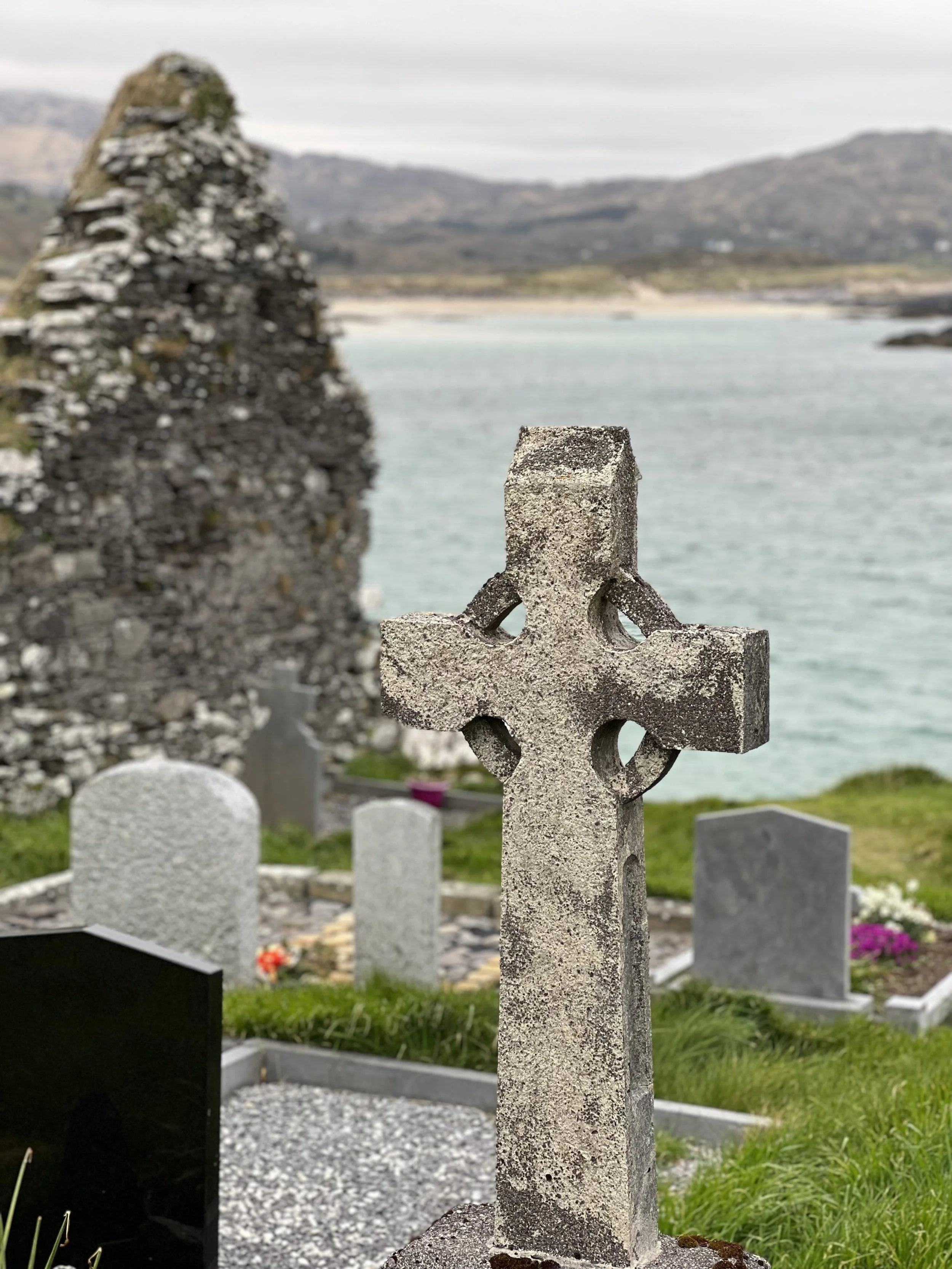
Such a gorgeous setting.

We continued around the southern edge of the Ring and passed through the village of Sneem. It looked like a charming village and a great place to stop, except for the six or so large buses that had already unleashed their throngs upon the town.
We continued on, arriving in the city of Kenmare. After a bit of window shopping, we popped into PF McCarthy’s pub for a couple pints of Guinness and some chips.

From Kenmare, we headed up the mountain pass and through Molls Gap.

Beyond Molls Gap, we stopped at a scenic turnout just above Ladies View (which is more picturesque in my opinion…sorry ladies!).

The real Ladies View scenic viewpoint was just beyond. The Irish Times called it one of the most photographed places in Ireland. The name comes from the admiration of the view given by Queen Victoria’s ladies-in-waiting during the Queen’s 1861 visit to Ireland and nearby Muckross House. In fact, the furthest lake in the distance is Muckross Lake.

Our final stop along the Ring was to see Torc Waterfall (meaning “cascade of the wild boar”), at the base of Torc Mountain in Killarney National Park. It is within walking distance of Muckross House, so Queen Victoria visited the waterfall during her tour of the region.
The word Torc is from the Irish translation of a "wild boar," and the area is associated with legends involving wild boars. One legend is of a man who was cursed by the devil to spend each night transformed into a wild boar, but when his secret was revealed by a local farmer, he burst into flames and disappeared into the nearby Devil’s Punchbowl on Magnetron Mountain from which the Owengarriff River emerged to hide the entrance to his cave beneath the Torc Waterfall.
There is also the story of how the legendary Irish warrior, Fionn MacCumhaill, killed a magical boar on Torc mountain with his golden spear.

Pesky magical boars aside, the view over Muckross Lake (foreground) and Lough Leane beyond was beautiful.

Another small waterfall is accessible by a hardy 15-minute hike beyond Torc Waterfall. Not sure it was worth the effort, but walking after all that sitting was a definite bonus!
Glenbeigh
Our cottage was in the small village of Glenbeigh, and these are some local sights.

Stones on the Rosseigh Stand.

Behy Bridge used to access our cottage.

The Glenbeigh Fairy Forest was a bit disappointing.


They were kind of boring, but they also look like they were made by local kids…I’m a real jerk for bagging on them! 😭

These were the cutest ones we found.

The rest looked like those Saturday projects you take your kids to at the Home Depot.


Pure Ireland!
Gap of Dunloe
Friday (Apr 28) was our final day in County Kerry and we decided to drive to the Head (summit) of the Gap of Dunloe.

The relatively short drive is one of the most beautiful places we’ve visited thus far in Ireland. Just look at the road on the left (above); it’s like a really long Lombard Street—only narrower, with two-way traffic, walkers, cyclists, and jaunting cars! Here are some clips from our drive https://www.youtube.com/watch?v=Csq9KXL-EBc:
As we were driving up the road we got the impression we were doing something wrong. Amanda went online and found that they prefer you hike or bike up the road rather than drive.
Oh well, we were committed at that point (and had definitely not set aside 5 hours for the round trip hike). At this time of year it wasn’t an issue, but I can imagine it being a real problem at the height of tourist session in the summer months.

At the summit, we talked with two women who had rented e-bikes from Killarney Bike Rental. They rode to Ross Castle where they loaded their bikes on a small ferry boat that took them across Lough Leane before continuing on the the Gap. Had we known about this option, it would have been an amazing opportunity. Just a heads up if you ever make it over here!
Ross Castle

Ross Castle is perched on an inlet of Lough Leane, inside Killarney National Park.

Despite the name, Ross is not a “castle” in the truest sense of the term. Ross is a tower house, which is a fortified medieval residence of stone, usually four or more stories in height. They were built widely in the fifteenth century as strongholds to protect local chieftains from unfriendly neighbors. Ross Castle was the ancestral home of the Chiefs of the Clan O'Donoghue, later associated with the Brownes of Killarney.
In fact, there are over 3,000 such tower houses littered across Ireland. Like most of the surviving medieval monuments, the majority of Irish tower houses are in poor condition, with collapsed walls and ivy shrouded exteriors, reflecting centuries of neglect. An increasing number are being restored through both private and state initiatives.
The name Ross comes from the Irish word meaning “headland,” so the castle is a family name, but rather a reference to its location on the headland of Lough Leane.

They did not allow photographs inside (I’ll never understand why places adopt this archaic and self-defeating policy), but here is a quick photos of Amanda in the Great Hall on the top floor.
The roof is pretty amazing. The original wooden roof collapsed from neglect, so they rebuilt this one based on probably the only tower house with its original medieval roof timbers intact—Dunsoghly Castle near Dublin Airport.

A boat crosses Lough Leane with Purple Mountain on the left.

A boat rests on Lough Leane.

This monument in Killarney of two stags represent the wild deer of Ireland. The Red Deer (Cervus Elaphus) in the Killarney area are the last of the native Red Deer in the wild. Their lineage is traced back over 5,000 years. A protected species under the Wild Life Act, they are part of Ireland’s national heritage.

While Amanda when shopping, I had a mocha at this café. If you’re ever in Killarney, go here—some of the best coffee I’ve had in a long time!
This was our final day in the Ring of Kerry and Killarney National Park region. Tomorrow we visit Blarney Castle on our way to our next place in the seaside town of Kinsale, outside Cork. May the road rise to meet us!