Shetland
“Shetland has always been a place of sanctuary for me. I visited when I dropped out of university, and I just loved it from the minute I got there. It’s a bleak but very beautiful place.”
An archipelago of more than a hundred islands, Shetland is one of the most remote areas in the United Kingdom. Its fifteen hundred miles of shore mean that wherever one stands, there is a view of the sea.
It has sheltered voes (a term used only on Orkney or Shetland to refer to a narrow inlet from the sea) and beaches and dramatically exposed cliffs and lush meadows full of wild flowers in the summer and bleak hilltops where only the hardiest of plants will grow.
Shetland is, of course, home to a special breed of pony, and Lerwick is home to Detective Inspector Jimmy Perez of the TV show Shetland, The Tall Ships Races, and the annual Up Helly Aa fire festival.

Man oh man, are we way in the middle of nowhere or what?!
On Sunday (Aug 6) we boarded the ferry in Kirkwall, Orkney just prior to midnight and drove off in Lerwick around 8 am on Monday.
The Bressay Sound has been a mariner’s haven for thousands of years, and Lerwick (Old Norse: Leirvik—muddy bay) has been, as it was for us today, its landing place.
We made the very short drive to our new house at 59A King Harald Street.
Sleep on the ferry was restless, so we both favored a nap over sightseeing; however, the day was gorgeous and both Tuesday and Wednesday were forecast to be cold and quite windy. We sucked it up and headed out to visit the sights on the south end of the island.
Sumburgh Head Lighthouse
Built by the famed Robert Stevenson in 1821, Sumburgh is the oldest lighthouse in Shetland. The lighthouse stands on the southern tip of Mainland Shetland.

See what I mean about the beautiful day?!


The foghorn at Sumburgh Head was first used in 1906. Air is piped to the horn house from the engine room to create the blast. The horn was positioned at a high point to allow the sound to travel further.
Originally, the horn could be rotated to change position; however, they no longer adjust its position so mariners can better judge the position of the horn.

The light was automated in 1991 and the keepers' houses were converted into holiday accommodation.

The fog horn and lighthouse.

The East Radar Hut at Sumburgh Head. Following the torpedoing and sinking of HMS Royal Oak by German submarine U-47 in October 1939, the Home Fleet had been temporarily withdrawn from Scapa Flow in Orkney.
In response, First Lord of the Admiralty Winston Churchill ordered the construction of several permanent barriers to prevent further U-Boat attacks which came to be known as the Churchill Barriers. He also ordered that the anti-aircraft defences be massively increased.

Once Scapa Flow was deemed safe again, the fleet returned in March 1940, but the Germans immediately began probing the defenses as a dress rehearsal for what was to come.
On April 8, 1940, as darkness fell on the eve of the German invasion of Denmark and Norway, some 60 Luftwaffe bombers crossed the North Sea in an attempt to neutralize the British Home Fleet at Scapa Flow.
The radar scope is the black box behind me.

Sub-Lieutenant George Clifford Evans was in charge of radar operations on this momentous night. Having detected a raid approximately 100 miles south-east of Sumburgh Head (19:55), he was able to communicate the threat and provide a 25 minute warning to the Admiral Commanding Orkney and Shetland based at Lyness in Hoy, on the western flank of Scapa Flow.
As the aircraft continued to be tracked, Evans stepped outside on a clear starlit night and witnessed a “tremendous firework display” as the Scapa barrage repelled the enemy attack.
A second similar attack was attempted again two days later on April 10, 1940, and it was similarly defeated due to early detection by the Sumburgh Head radar station.
Had the raid of April 8 succeeded, British naval power would have been compromised, potentially influencing the course of World War II in what has been described as “the Pearl Harbor that might have been.”

Farwell Sumburgh Head.

A snack for the road—not! 😝

Sumburgh Airport is at the south end of the island, near the Sumburgh Lighthouse. Lots of massive S-92 helicopters operating, which are super fun to watch.

Sumburgh is a true island airport, nearly surrounded by water.

Interestingly, the road (A970) actually crosses the departure end of runway 09 (which the winds were favoring when we crossed to reach the lighthouse).

There are gates on either side of the runway, with a person stationed at each. Anytime a plane is departing or landing, they activate the red lights and manually close a gate across the road. Such a janky small town operation! 😆

We’ve seen poser Shetland ponies before, but these are the real deal—OG baby!
St Ninian’s Isle Beach

St Ninian’s Isle beach on the west coast of Shetland is a large natural sand causeway with sea on either side that links the South Mainland with St Ninian’s Isle.


This kind of sand causeway is officially known as a tombolo, although the Scottish word is ayre. Whatever you call it, this is certainly one of the most picturesque beaches on the islands.

On St Ninian’s Isle looking south to Sumburgh Head and the lighthouse.

St Ninian’s Chapel is the remains of a small stone church from the 12th century.
There is evidence along the lower courses of the walls for an even earlier historic church.
There are also remains of Iron Age settlement from around 800 BC to AD 400.
The church was revealed by excavations conducted between 1955 and 1959, which famously discovered an unparalleled hoard of Pictish silver objects.

The stone marker next to Amanda marks where, in July 1958, a Shetland schoolboy named Douglas Courts was sent to dig in a heavily disturbed area of the nave. It was his first day at the excavation site. Douglas turned over a broken stone slab with a cross incised upon it. Underneath he found a wooden box, inside of which were 28 silver objects and the jaw bone of a porpoise.
The silver was elaborately carved and in many different styles. It is generally assumed the treasure was buried below the floor of an earlier chapel. The collection was most likely hidden for safe-keeping from Viking raiders, and probably belonged to a wealthy family.
The original items are now on display at the National Museum of Scotland, which we’ll now have to go back and visit.
Shetland TV Series

Without the TV series based on the Ann Cleeves mystery crime novels, I’m not sure the ponies would have been enough to draw us all the way to the furthest reaches of the UK.
The show highlighted the islands in a way that made them mysterious and inviting. And so here we are.

Literally two blocks from our house is the Lerwick Police Office. This building is featured often throughout the series, although the entrance to the police office is actually around the corner to the right.


The square crenelated clock tower of the Lerwick Town Hall is featured consistently on framing shots of the town.


The Market Cross is another favorite (and look who’s been in the charity shops again!!)


The Lounge features throughout the Shetland series, but it has a reputation of being rundown, so we never went inside.


Cool embossed rope over this door on Commercial Street, Lerwick’s “high street.”

The famous Bain’s Beach (aka Queen’s Beach).

The steps to Bain’s Beach.

On Bain’s Beach

As forecasted, the weather was a-changin’.

Finally, the holy grail—the house of DI Jimmy Perez. (The viking boat in the previous image actually shows up in the background of scenes shot at the house.)


Perez’s house and the one at the end of Bain’s Beach were once lodberries.
In fact, much of the downtown Lerwick shoreline was once covered with beaches, piers, and lodberries.

The word “lodberry” comes from the Old Norse “hladberg,” which means landing rock. A lodberry was a store or enclosed courtyard built into the sea with a door through which goods could be loaded or unloaded by boat.
Smugglers hid alcohol, tobacco, and tea in the lodberries. Some houses had underground tunnels linking them to the lodberries so goods could be moved quickly and secretly to avoid paying taxes.
The Lanes

The downtown area is filled with narrow lanes forming arteries running east and west between the residential area above known as Hillhead and Commercial Street below, which is the main thoroughfare of the old town centered on the harbor.

Buildings in this area are closely packed together and, owing to the steep terrain, the majority of the lanes include flights of steps and handrails. Some are so narrow as to be almost impassable.

In 1845, for reasons lost to time, the Police Commissioners arbitrarily re-named many of the lanes or “closes” as they were previously termed, discarding old names that reflected well-known local identities and choosing new ones to commemorate far-off events and individuals such as the Whig politicians Pitt and Fox.

It seems, however, that there may have been some rebellious citizens who were unwilling to accept the new names or at the very least insisted upon keeping the old ones as well.


Thus today many of the signs incorporate both street names, like above. (Interesting how they spell “close.”)

Of course, it is not the names but the quirky twists and turns that characterize the lanes and give them their appeal.

So amazing to be on Shetland!
Wednesday

On Monday we headed south, so on Wednesday (Aug 9) we headed to points north—like the locally famous Frankie’s Fish and Chips.

The St Magnus Bay Hotel from the Shetland TV series.

The beautiful bay near Braewick, with the Drongs sea stacks in the distance.

Stenness Bay was the site of an important haaf (deep-sea fishing station) in the 18th and 19th centuries. The fishing station was once one of Shetland's busiest, with up to 40 boats operating from this small bay throughout the summer.

All the workers lived at the station during the fishing season. The remains of their lodges, the roofs of which were once covered with poans (turf), can still be seen today along the beach and around the headland.

The cross on the adjacent hill was erected as a meid (sea mark) for the tenders coming ashore to resupply the nearby Eshaness lighthouse. The high cliffs made landing close to the lighthouse impossible and Stenness was identified as the closest safe location.

Just off the coast sits Dore Holm, a small uninhabited islet with a natural arch. The first part of the name appears to be derived from “door,” and the word “holm” is of Scandinavian origin, meaning a small island. The shape of the arch has been compared to a horse drinking deeply from the water.

The Eshaness Lighthouse.

Can you tell it’s 50 degrees, with 25-35 mph winds, gusting to 50 mph? It was hard to stand up at times.

“All along the ragged coastline, the sea sucked and frothed and growled, tireless legions of riderless white horses crashing up against the stubborn stone of unyielding black cliffs.” Peter May, The Lewis Man (89)

Later that afternoon, the sunlight dappling on the sea and the Drongs sea stacks

Finally some Highland Coos.

With bells on no less.


Love this little guy.
Avril Thomson-Smith
Over the past few days, we noticed and appreciated art by local artist Avril Thomson-Smith. When Amanda looked her up, we found she had just opened a storefront in Lerwick in May.

On Wednesday afternoon, we stopped in the shop and met Avril. We eventually settled on a print of her painting High on the Hill - Cunningsburgh. The print is being shipped to our house.


To celebrate purchasing the painting, we stopped at The Dowry and had a pint of the local Lerwick Brewery’s lager named 60 Degree (referring to Lerwick’s latitude). 👍 👍
Thursday

Avril told us roughly where to find the croft from the painting, so we drove there today (Aug 10).
Here is Amanda standing high up on the hill, near the croft, with Cunningsburgh Bay in the distance.

The croft as it really looks.

We also made the short drive to Minn Beach, which had a tombolo (ayre) much like St Ninian’s Beach from Monday.

Back in Lerwick, another beautiful old lodberrie at Gillies Pier (formerly Copland’s Pier) on Commercial Street.

Cool garage!
59A King Harald Street, Lerwick
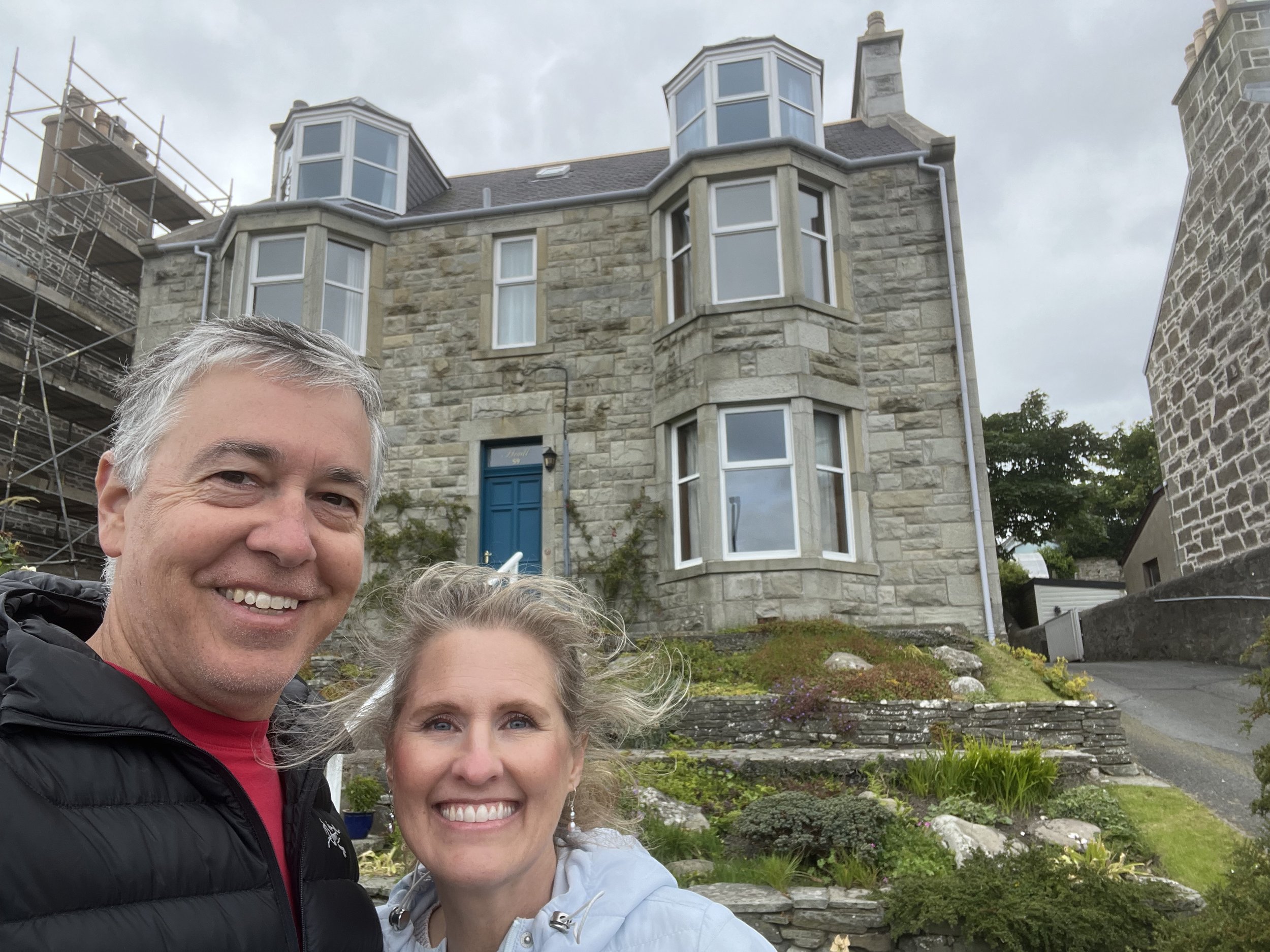
This is our house in Lerwick, where we had the entire lower floor. The owner Violet lives in the two upper stories. (There is no internal connection between the first and second floors.)

We love how many of the houses have official names.

The view of Lerwick Town Hall from our living room window. Below is a belated tour of the house: https://www.youtube.com/watch?v=rVsynZHdIgU
On Friday (Aug 11) we board the 5:30 pm ferry and travel overnight to Aberdeen, back to mainland Scotland.