Helvellyn
“I went whenever I could, and always my eyes lifted to the hills. I was to find a spiritual and physical satisfaction in climbing mountains and a tranquil mind upon reaching their summits, as though I had escaped from the disappointments and unkindness of life and emerged above them into a new world, a better world.”
Traditional Fingerposts
On the way to the trailhead for Helvellyn, I passed several traditional fingerposts. These cast iron posts, painted with black and white bands and the County embossed down the center, include cast iron "fingers" that provide directions.
The sign below has been beautifully restored.
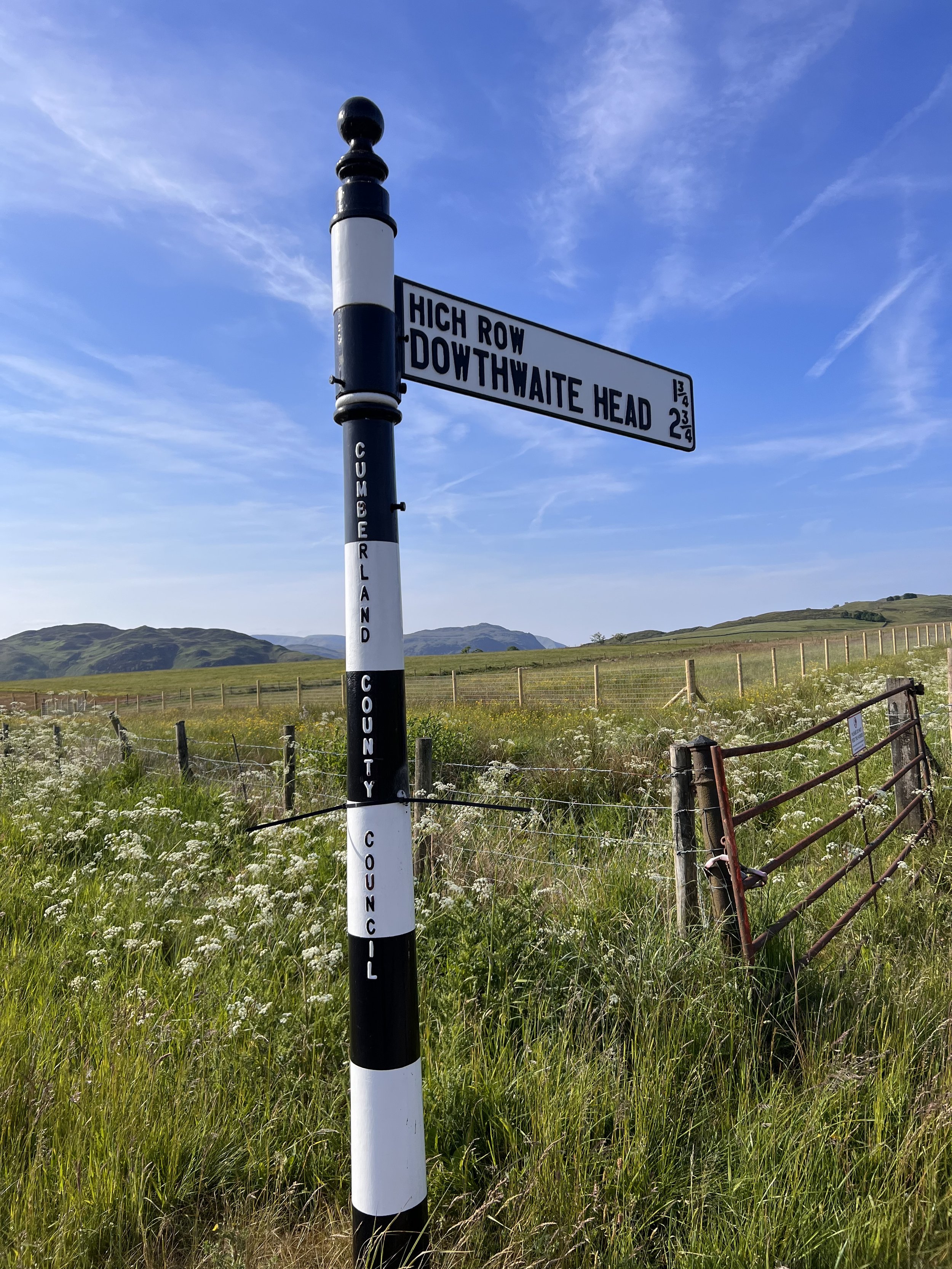
Anticipating invasion by the Nazis, the government insisted all signposts were removed. In some cases the posts and fingers were melted down for the war efforts. In other instances, the posts were left but the fingers were removed and either buried at the foot of the post or collected and stored at a designated site.

The sign above needs a good scrubbing, but it’s an example of the those with a donut on top that indicates you are in a village—in this case Dockray.
Most fingerposts were put back in the late 1940s. However, with the invention of GPS, the signs are no longer considered essential.
There are about 150 still in existence in the former Cumberland and Westmorland council areas, dating back to the late 1940s or early 1950s.
About ten years ago an effort was begun to preserve and restore the sign posts based on the idea that they added to the character and identity of villages in Cumbria.
Much like the beautiful posts we saw throughout the three “Ridings” in Yorkshire, their Cumbrian counterparts are quite beautiful and I agree wholeheartedly that they add a distinctive, nostalgic regional charm that should be conserved.
Helvellyn
As the third-highest peak in England, Helvellyn is obviously a “Wainwright” fell.

There are multiple ways to reach the peak, but I wanted to cross a ridgeline known at Striding Edge. For this reason, I drove about 45 minutes so I could begin in the village of Glenridding. Here I am just starting up the trail from Glenridding with the gorgeous Ullswater in the distance.
The following map is centered on Helvellyn, but you can also see Glenridding and Ullswater to the right (you can pan around and zoom in and out on the map).

A foxglove and ferns in the foreground, Glenridding in the valley below, and Ullswater in the distance—so beautiful!

The tiny Lanty’s Tarn just beyond the gate.
Tarn isn’t one of those new local terms to learn. A tarn is a mountain lake, pond, or pool formed in a cirque excavated by a glacier. A cirque is an amphitheater-like valley formed by glacial erosion.

As you’ll see—from tarns, to arêtes, to cirques—this entire region was shaped dramatically by glaciers. It’s very much like Yosemite, only without all the dramatic granite cliffs.

The trail traversed ever higher up this mountain side, along the amazing Grisevale Valley below.
Section 4 of Alfred Wainwright’s classic 190-mile Coast-to-Coast Footpath travels through this valley, typically from the far side of the valley (west) toward the camera (east).
Hole-in-the-Wall

After a steep climb I finally arrived at the landmark known as Hole-in-the-Wall (no clever Lake District vernacular here!). I ate my delicious pasty on the other side before crossing through here and having my photo taken.
This essentially marks the start of the section known as Striding Edge.
Striding Edge
Striding Edge in an arête—a narrow ridge of rock that separates two valleys, formed when two glaciers erode parallel U-shaped valleys.

Clouds Rest in Yosemite National Park is an arête that my sister Debbie and I hiked in June 2007. Go Debbie!

Starting across Striding Edge with Red Tarn below and Helvellyn in the distance.
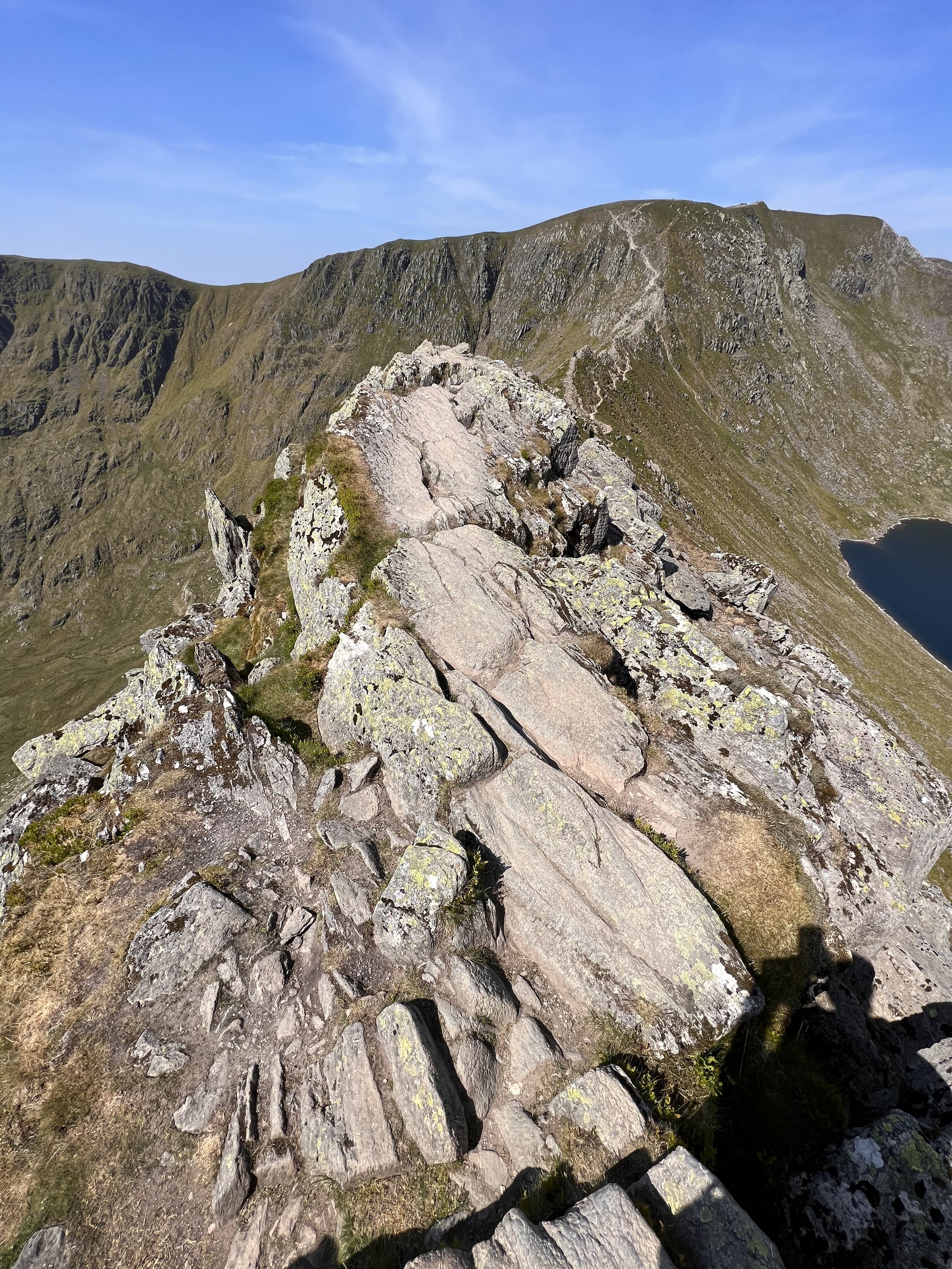
From here you can see the knife’s edge you carefully walk across. The two obvious U-shaped glacial valleys on both sides—Red Tarn is to the right and Nethermost Cove to the left.
Here is a short video compilation of the trip up to this point: https://www.youtube.com/watch?v=lELEwe7Q9yw

This probably won’t translate to a picture, but above is where the rocky top of the Edge stops abruptly, forcing you to downclimb. It’s only about 30 feet down, but it made for a slightly technical task that made me feel good—once it was over. The photo below probably captures better the technical descent required to get off the Edge.

If the hazards associated with crossing Striding Edge aren’t glaringly obvious, there are signs.

Like the iron monument above that I found at the end of the Edge, memorializing 33-year-old Robert Dixon who plunged from the ridge on November 27, 1858. I’m not sure the end of November is the ideal time to be up here.

Here I am at the end of Striding Edge, looking back on where I came from. You can see there is an option to remain below the Edge. I’ll give you three guesses which route I chose, and the first two don’t count…

If you think the fun ends when Striding Edge runs out, think again. The final push to the top of Helvellyn was nearly as sketchy.
From here you can roughly make out the trail, but once you are there, the path is anything but defined.
Your primary obligation is to remain away from the edges, and pray no one above you sends a rock tumbling down. It was an exhilarating final push to the summit to say the least.

Here is the drawing of me, red shirt and all, from inside our apartment!

And then, just like that, you are out of harm’s way and back onto a relatively smooth path.

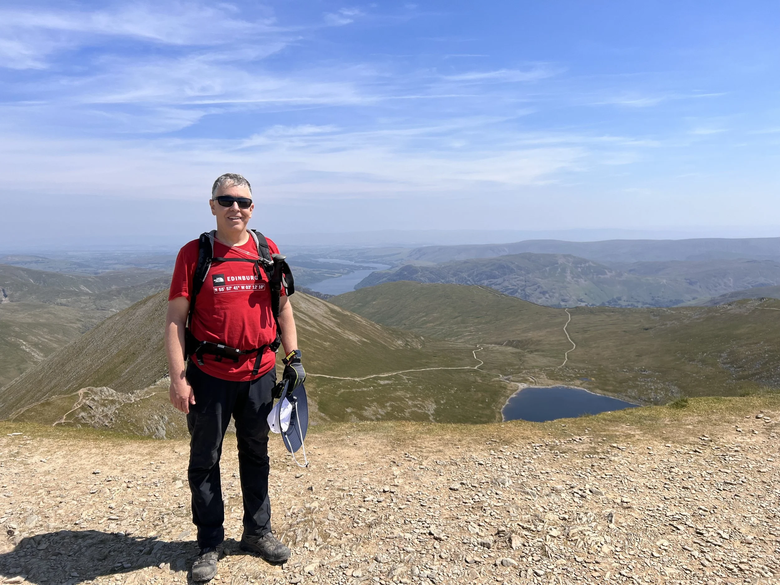
Looking back on my accomplishment! Phew! 😅
If you look for the fairly obvious pathway leading from the tarn up to the saddle in the distance, that is where Hole-in-the-Wall is located. I came up from the other side of that saddle.
William Wordsworth's home at Rydal Mount is fairly close to Helvellyn, so he hiked to the pike often. His poem Inmate of a Mountain Dwelling (1816) celebrates Helvellyn.
John Keats speaks of Wordsworth "on Helvellyn's summit, wide awake…" in a sonnet that celebrates the poet and other artists.
And then there’s the artist Charles Gough.
Charles Gough
Charles Gough (1784–1805) was an artist of the early English romantic movement in the 18th and 19th centuries.
Gough was a tourist visiting the Lake District from Manchester in April 1805, when on 17 April (very early in the hiking season!) he decided to walk over Hellvellyn to Grasmere. He took his dog Foxie with him and set off via Striding Edge. He was never seen alive again.
Three months later on 27 July a shepherd heard barking near Red Tarn, and on investigating, discovered Foxie beside the body of her master. The shepherd summoned assistance, and a crowd returned to the scene. They collected skeletal remains and some of Gough's belongings, which included fishing tackle, a gold watch, silver pencil, and two Claude glasses. Also recovered was Gough's hat, which had been split in two. From this it was surmised that he had fallen to his death from Striding Edge.
Foxie was found to have not only survived the months beside her dead master, but had also given birth to a puppy, which died shortly afterwards. The healthy dog and the skeletal remains of Gough led a Carlisle newspaper to report that the dog had “torn the clothes from his body and eaten him to a perfect skeleton.”

As you near the summit of Helvellyn, you reach this memorial stone to Gough, which was erected in 1890.
While the memorial reads “beneath this spot…” the term should be taken rather loosely. If by “beneath” they meant: if you fall from the top of the mountain (where the memorial stands) all the way down to Red Tarn hundreds of feet below, then, yes, “beneath this spot” does work.
Gough’s death was commemorated in poems by Wordsworth and Walter Scott and by the painter Edwin Landseer. The memorial stone quotes part of Wordsworth's poem "Fidelity.”

I added this photo several days after publishing this blog. This photo was taken by Ambleside photographer Herbert Bell during the 1890 installation of the memorial.
Canon Hardwicke Rawnsley (front center) was a charismatic and passionate man, whose devotion to protecting land from development and energetic campaigning style led to his well-deserved nickname of “Defender of the Lakes.” His belief in preserving the natural landscape for everyone to enjoy forever is as important today as it was over 125 years ago, when he helped to found the National Trust.
Rawnsley collaborated with the writer Francis P Cobbe to install the Gough monument.

It’s hard to get numbers more round than this: 3 hours and 4 miles to the summit.

The view from the summit, Ullswater is the far distance and Striding Edge to the right of Red Tarn.

A panoramic photo from the summit.

Ordinance Survey Bench Mark S5948. In the UK they call these fixed surveying makers “trig points,” and most major peaks have them.
Swirral Edge

Swirral Edge is the path down the opposite side of the cirque. Although it’s an exposed scramble down, it was a relatively straightforward descent.

Once at the bottom of Swirral Edge, it was a simple rocky path down to Red Tarn below.

Striding Edge to the left, the final climb segment just right of the pronounced cleft, Helvellyn pike, and Swirral Edge to the right. Red Tarn is just visible. Phew!
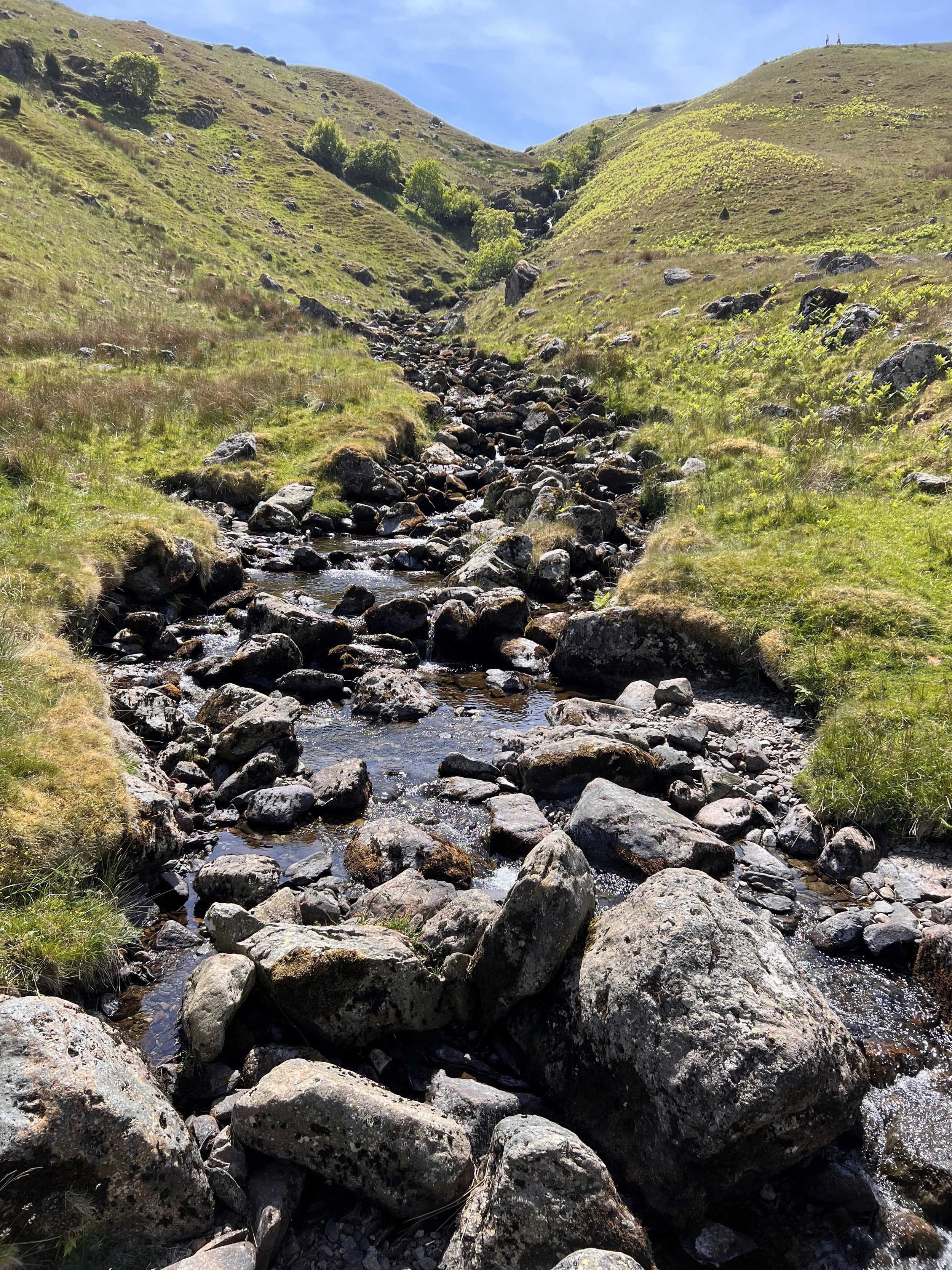
It ain’t over yet folks! From Red Tarn, you still have over three miles of fairly steep descent to get back to Glenridding. At least the trail is fairly easy, not to mention very pretty in places!

Nothing better (or more apropos) than a fresh pint of Wainwright ale at the aptly named Travelers Rest pub back in Glenridding.

Final Details:
Elapsed Time: 5 hours and 54 minutes
Total Distance: 8.26 miles
Elevation Gain: 2,892 feet
Not too bad for an old man! 😝
On to the next one…